How do you find the spirit and play of exploration in an optimized geography?
In the idiom of maps and cartography, the tendency is to thoroughly identify as many attributes of the physical world and coordinate them to geographic, you know…coordinates, typically using latitude and longitude. Those attributes are usually other instrumental and worldly markers, like street addresses, nearly immovable physical markers like, you know…landmarks, buildings, franchise stores, and so on. The database tables fill in with this information, sorted, sifted, refined. Some deletes and updates.
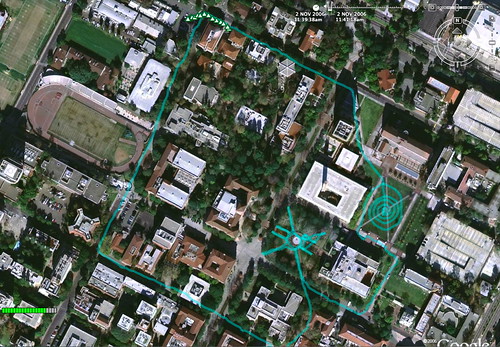
In between the record sets are the most interesting possibilities for new services, new ways of experiencing the physical world and new kinds of adventures. What I’m thinking about are ways to creatively explore within a fully instrumented, surveilled and mapped world, with counter intuitive uses of this data. There are some excellent examples within the art-technology and design-technology communities, such as GPS Drawing, as shown above. This practice is intriguing because it couples measurement with expression and finds an alternative use for the devices involved — a GPS and a mapping application like GoogleEarth.
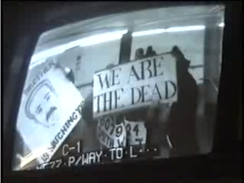
Surveillance Camera Players using CCTV cameras as a site for performance opportunities
Younghee wonders, in this context, what are the ways of minimizing “digital traces” — those indications of where you are, and where you have been, in a surveillance world. She says,
That leaves another interesting question: How would people drop out of, or at least minimize their digital traces and minimize contributing to create others’? We are probably not expecting stickers and badges showing “this person does NOT have cameras” or “this person will NOT use cameras”. One of the memorable Ubicomp conference talks was on the interesting concept of creating capture-resistant environment, preventing camera phones to take photos by overexposing photos attempted in the region covered by this technology. While I am sure there are certain types of places this technology would be very useful, I do have my doubts if there would ever be any technology successfully controlling people’s digital behaviors.
Similarly, in a reverse mode, Life: A User’s Manual by Michelle Teran captures the signals leaked into public space by RF-based video cameras and reveals intimate spaces in a very DIY and performative fashion.
Minimzing traces is one possible perspective. I think, perhaps in this era where digital kids do not reflect so much on how much of a trace they leave behind, and indeed have entirely different perspectives on the meaning of surveillance and its implications. How many digital kids (the next “us”) have read “1984” for example?
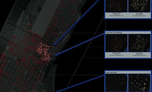
In contrast to the Surveillance Camera Players and their performances — where they are maximizing their imact and traces for counter-intuitive purpsoes, and counter-systemic purposes — groups like the Institute for Applied Autonomy have constructed — years ago, pre-Google Maps — a digital map system called iSee of surveillance cameras that would allow one to plot a course that does precisely what Younghee wonders about — minimzing one’s impact. In other words, the mapping system plots routes that avoids surveillance cameras.
It may be that the question is no to much avoiding “capture” but how to turn that space into something where your voice can be heard. I’m not convinced, but it seems that we (a bit older people) think of surveillance in one way that digital kids (the next “us”) will see as an opportunity for a new form of living.
Beyond this, I am interested in a kind of Personal Positioning System that points out the absences in my experiences in the world. For example, showing me where I have not been rather than showing the entire world from above, as if its fully prepared for my exploration. I’m interested in finding things like longer route between two points, rather than the minimal route. Or routes that are deliberately constructed based on streets or regions I have not been. Purely as a form of creative, digital-era perambulation or motoring. Exploration in a world that is pretty much completely mapped, indexed, databased and optimized. What is exploration in an optimized, instrumented world?