Service Ecologies and The Geospatial Web

Mike Liebhold is here today to talk on the topic of the Geospatial web.
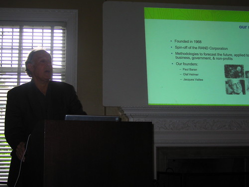
What does the IFTF do?
Brainstorm through possible, plausible, probable and preferred futures. Present a context for understanding the future. Up to clients to develop insights based on the foresights. Foresight to insight actions is the operating principle of the company.
Research areas are sociological impacts of technology.
Some IFTF clients: AMA, Johnson Johnson, Alstate, Intel, Pepsico, Lego, Kraft, Kodak, Honda, McDonalds.
Methodologies: Mapping, Ethnographic, Expert workshops interview; Scenario development analysis; Surveys quantitative analysis (sort of..); content facilitation; prototyping/artifacts (building objects from the future.)
Internet Platforms: Root Fragmentation?
* US / ICANN vs ITU / UN
* The Chinese future of IPv6
* Economies of scale drive specifications
* The Golden Shield
What happens if the US holds onto ICANN and others want to split off the root server infrastructure?
What is the lesson here? Chinese are buying lots and lots of Nextel, etc., so they can influence technology design by virtue of their force in the economics of design they can say what they’ll buy and when they’re buying lots of something, they can shape design and thereby create protocols or variations of protocols independent of task forces.
Platforms: P2P Networks
* Mesh Networks
* Automotive Nets
* Sensor Nets
* Self-configuring Nets
What is interesting here? http://www.caida.org creates great traceroute maps of the Internet.
Security: Biometric Authentication
Usage: Immersive Entertainment
Trend in the future for web-like experiences out in the world. Leads to the Geospatial Web.
What is interesting here? Imaginary world draped over physical world. Long standing area of interest for Mike. Profound new kind of world wide web, hypermedia objects are not just identified by URI or URL but by spatial coordinates – lat/lon/elevation. What are these? Text objects; sounds; images. Enormous amount of cartographic data that should be viewed in situ. Invisible attributes become visible. Sentient landscapes. Context-aware computing.
Geoweb Geospatial Ecosystem
* Geolocation Techniques
** location-aware software (triangulation)
** location-aware devices (e.g. GPS)
** location-sensing networks (e.g. E911)
What is interesting here? General concern with privacy, partially because there aren’t open systems for these.
Placelab.org is an alternative, because it’s open. Telco carriers have the location info, but they won’t make it available because they want to charge you or worse. So the economics of that proposition are not compelling to end users who don’t want to feel like they’re getting nickel-and-dimed.
* devices for augmented perception
** smart phones PDAs
** automobile computers
** body extensions (pens, cameras, earphone rigs, pens)
What is interesting here? Not at all clear how the device ecology will evolve.
* location-aware services
** walled gardens (sadly..)
** carrier services
** enterprise servcies
** Google Earth
** MS Virtual Earth
** Sony XYZ;head-mounted video, dashboard graphics.
What is interesting here? You may want to hold up a device to see things as you move around, rather than on a downward facing screen.
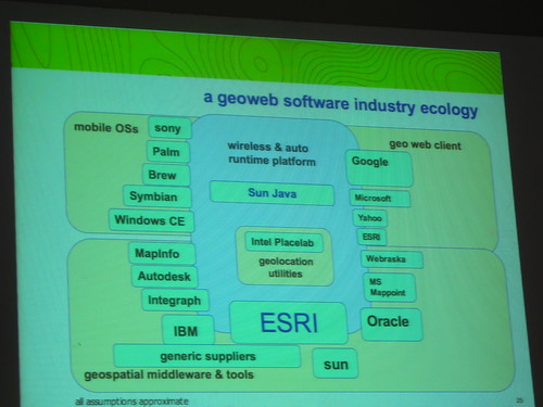
Geoweb Software Industry Ecology

What is interesting here?Open mapping services allow you to import standard maps into Google Maps — detailed in new book called Google Map Hacks by O’Reilly.
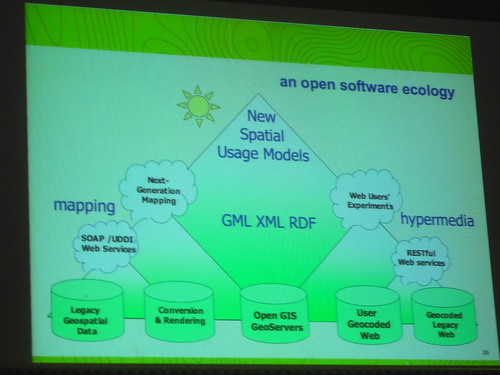
an open software ecology

What is interesting here? There’s a software ecology and an industry ecology and a bit of confusion amongst them. Or maybe it’s that the two “ecologies” don’t overlap in that the industry ecology does not open up their platforms to the software ecology. Walled garden problem.
geospatial policies
* contextual privacy
* freely accessible geolocation APIs
* public geodata services
What is interesting here? Interesting practices for creating geodata; individuals, local groups, creating their own maps through grassroot means, and spunky, hacky techniques such as walking/riding with GPSs. Same sort of way that NAVTEQ does, only open. Also, Institute for Applied Autonomy’s iSee.
Geodata Search
* clearinghouses
* gateways
* repositories
* namespaces
* geoweb servers
Integrated GIS Web Hypermedia / Realtime Cubit Cartography
Usage: Computational Grids
* health mapping
** epidemiological + environmental maps
** health resources
** risky places
** people at risk
* security
* Geo Demographics
** microzone advertising
* at-risk ecologies
** eco-tourism
** green mapping
** indigenous mapping
* path-making (capturing folkloric knowledge of a place)
* pixel views: fragmenting places and spaces (micro views into a farm field)
* ground truth: empowering people in place (creating your own community information and stories in place)
Technorati Tags: geospatial web, locative media, Service Ecology