Publications

Writing

Coherent Light: Virtual Reality and the Cultural Politics of Technology. Masters Thesis. University of Washington, Seattle. (1992)

Virtual Reality and Vision Culture. Essay on the significance of virtual reality in a culture dominated by vision and visual phenomenon. Afterimage, vol. 20, no. 3, October 1992.

Narrativity in Virtuality. Introduces video and film artists to new conceptual forms of interactive narrative suggested by virtual reality. National Alliance for Media Arts and Culture (NAMAC) Journal, January/February 1993.

Incorporations: Zone 6. Book review of a compilation of writings on the ever changing relationship between humans interfaced and interacting with technologies. Afterimage, vol. 20, no. 9, April 1993.

Criminal Violence and the Video Game (1994)

Urban Crisis: Past, Present and Virtual (SR, Winter 1994-95, v. 24, no. 1-2. Reprinted in SimCity: Mapping the Virtual Cities, Matteo Bittanti, ed. 2004) [“SimCity paper”]

Virtual Reality and the Politics of Technology (Left Curve, Issue 18, c. 1994)

The Race for Cyberspace: Information Technology in the Black Diaspora. With Ron Eglash, Science as Culture, Volume 10, Number 3, September 1, 2001, pp. 353-374.

The Reality Effect of Technoscience (Ph.D. Dissertation, UC Santa Cruz, 2004)

“A Design Approach for the Geospatial Web,” The O’Reilly Network, June 7, 2005.

What’s Your Social Doing In My Mobile? Design Patterns for Mobile Social Software. WWW 2006 Workshop on Empowering the Mobile Web. Edinburgh, May 2006.

Design Fiction: A short essay on design, science, fact and fiction. Independent essay on science and its reality effects through its fact and fiction idioms. March 2009.

Biography, Curriculum Vitae, Work Samples, Press, Professional Statement

Bleecker Headshot Timo Copenhagen

Julian Bleecker is a Research Fellow at the University of Southern California’s Annenberg Center for Communication and an Assistant Professor in the Interactive Media Division, part of the USC School of Cinematic Arts.

Bleecker’s work focuses on emerging technology design, research and development, and concept innovation in the areas of pervasive media and mobile entertainment. His focus is on designing and prototyping technology-based networked applications that anticipate near-future forms of mobile and pervasive experiences.

Bleecker has given talks and exhibited many of his emerging media and art-technology projects, designs and concepts in venues such as SIGGRAPH, Lift, Xerox PARC, O’Reilly Emerging Technology Conference, O’Reilly Where 2.0 Conference on Location-Based Technology, Ubicomp, Ars Electronica, ACM SIGCHI, ACM Advances in Computer Entertainment, Banff New Media Institute, American Museum of the Moving Image, Art Interactive (Boston), Boston Cyberarts Festival, Reboot, Eyebeam Atelier (New York City), and SK Telecom’s Art Center Nabi (South Korea). Before joining USC, Bleecker worked as an entertainment technology consultant, creating mobile and networked applications for commercial entertainment clients.

Bleecker has a BS in Electrical Engineering from Cornell University, an MS Eng from the University of Washington, Seattle, and a Ph.D. from the University of California, Santa Cruz where his dissertation was on the relationships amongst technology, entertainment and popular culture.

Professional Statement

Research Statement

Extended Research Statement

Resume

Curriculum Vitae

Press Binder

Work Samples

www.techkwondo.com

research.techkwondo.com

What The Experts Fail To Grok About Google Maps

I wrote a super quick, super short comment to a recent editorial on Directions Magazine’s site:

http://www.directionsmag.com/editorials.php?article_id=2012

My point was to indicate one of the important characteristics that I feel the editorial missed as it pitted experts against the wide-eyed, bushy-tailed novices creating Google Maps mashups. In a word — collaborative mapping. The ability for many hands, eyeballs, brains and sensibilities to contribute in a collective fashion to map making and world viewing. I’m going to start a new category — collaborative cartography.

I may’ve read your dispatch wrong, but calling for GIS experts to stay at their posts suggests a kind of narrow perspective on what’s changing in the world of locative media and services — collaboration.

Experts’ GIS systems for all their sophistication are far behind in their ability to provide the kind of massively multiparticipatory collaborative mapping that something as “basic” as Google Maps provides, right out of the box, and for a negligible cost. Pretty soon, if not already, GIS systems as we know them today will be as cranky and useless for their inability to dynamically correct through the collaboration of hundreds to millions of contributors.

There’s no questioning the sophistication of a self-regulating social formation of many, many cartographers working on creating maps of everything that matters to them, including the infrastructure maps you privilege. I could map right now, without ESRI and for all to see, including my local water utility, the leaky main in the back alley. Is the guy in the public works office downtown going to be able to do that? Maybe yes..but why should it’s right here 30 meters from where I sit?

Why do I blog this? I’m interested in the production of experts and expert knowledge. Not so much from the perspective of the knowledge itself, but mostly from the production of knowledge, how experts come to be experts, and how experts manage and police the boundaries between themselves and non-experts and the other way around — how non-experts situate themselves in relationship to experts and why.

Technorati Tags: , , ,

Ephemera Cache Game?

I’ve been thinking about using the Ephemera Cache as a framework for some kind of game experience.

I’ll put together ideas off of the Ephemera Cache wiki page.

Why do I blog this? I’m trying to think of ways to work through the one question this project brings to the fore: how can autonomous, motile networks create exciting and active social formations? So, I thought if I had a mobile, location-based digital media swap meet or blue gem game or something, I’d have the framework for an experiment that would give me some practice-based insights into what’s so curious about these ideas.

Technorati Tags: , , , , ,

LA Weekly: Digital Universe

Holly Willis wrote a piece describing the burgeoning digital art scene in Los Angeles titled LA Digital Universe in which she interviews myself, Perry Hoberman, Michael Naimark, Mark Allen and some others in the local tribe.

Why do I blog this?  The vanity angle is one reason, and the angle that good-press is good-news for someone who is sometimes orienteering towards art practices because it’s one way to do research at the edge of the innovation network. It also is nice to think that there’s a strong digital arts+technology scene in my new locale. It was hard to leave New York City because I thought I was moving away from an art-tech community that took me a couple of years to become part of. Kind of a closed boys world, it was. Almost like a frat.

Response to Michael Liebhold on The Geospatial Web

The following are my remarks on Michael Liebhold’s talk on The Geospatial Web, capture in my notes.

Mike insights and thinking on the promise of the Geospatial Web, as well as the necessary systemic alterations in the current service/media/business ecology are fairly well articulated in his essay The Geospatial Web: A Call to Action — What We Still Need to Build for an Insanely Cool Open Geospatial Web. His talk on the topic of the Geospatial Web fills in some of the questions surrounding what the Geospatial Web is, as well as what would make it happen and what is preventing it from happening.

My remarks on the talk pertain in part to what I think is the kernel of The Geospatial Web challenge: it is one of those bold visions tha’s as compelling as it is intractable in practice.

Why is it compelling? For many in the extended tribe of Geospatial Web enthusiasts, practitioners, hackers and visionaries, the idea of extending that data-rich and network-enabled environment best represented by the Internet (canonical, capital I) out into the world in which social bodies drive cars, walk down streets, throw punches and reach for their wallets means opportunities for creating new kinds of social formations. Liebhold outlined some possible scenarios, many of which are easy to imagine. I’m looking forward to the unexpected scenarios that cannot possibly be anticipated. I’m talking about the Geospatial Web-enabled experiences that really create a new arrangement of social interaction or circulate culture in a way that is far from doing the same old thing (e.g. buying some music) with the same old device (e.g. my cell phone) through a half-heartedly designed usage scenario (e.g. when I walk by an advert for a new Cold Play album.)

Why is it intractable? Well, not intractable forever, but certainly exceptionally stifling to my own personal style of innovation — the late-night hack motivated by passion for some completely off the wall idea. This is much of what Liebhold was referring to when he discussed the various “ecologies” that pertain to the Geospatial Web (see my talk notes). The Industry Ecology is made up of carriers, handset manufacturers, operating system developers, toolkit developers, business economics, content developers/deployers (media networks, apps developers, games developers), paying customers, with the carriers maintaining a somewhat heavy-handed authority over that kingdom. They own the customers, own the handset manufacturers in that they dictate what the handsets are able to do, dictate what operating systems will run on them, etc. Carriers are at the top of the “value chain” and want to stay there. But the value chain is untenable; it stifles innovation because the loop is closed. One palsied entity is dictating the terms of the entire ecosystem.

But there are ways in. It’s not possible to imagine, really, that everyone in the carrier world is interested in stonewalling innovation, or that there aren’t insightful clusters of intelligence therein that recognize that the opportunity for sustainability and growth is not about charging customers a nickel to let them know where the nearest gasoline station is.

One way in is to prove the business-economy case that open systems, cooperative practices and embracing the kinds of designed mobile experiences that are happening at the edges of the network are a viable, even necessary path to growth. Another approach I discussed with Liebhold and Francois Bar is the MVNOmobile virtual network operator. These are “white label” mobile operators, contracting for network usage from the big carriers. Essentially, they are branding and marketing exercises — cobble together your own Service Ecology and try to sell it through to your demographic. Often times these MVNOs offer a unique suite of applications and services targeted toward a particular audience — it might be music downloads, push-to-talk, chat..whatever. I suggested that one way a carrier might experiment with an open style Service Ecology might be to develop their own MVNO — sort of like what United does with its Ted airline service. It becomes a way to run an idea up the flagpole, and see who salutes.

Technorati Tags: , ,

Michael Liebhold Talk

Service Ecologies and The Geospatial Web

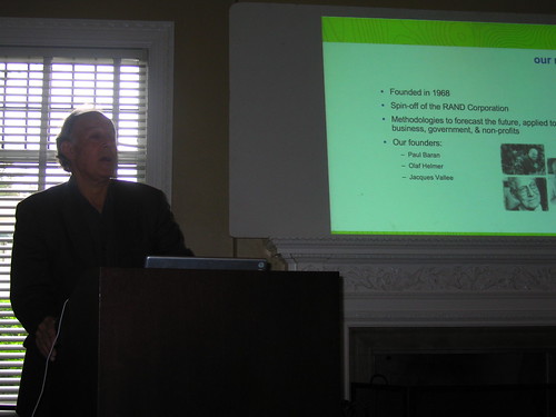
Mike Liebhold is here today to talk on the topic of the Geospatial web.

What does the IFTF do?

Brainstorm through possible, plausible, probable and preferred futures. Present a context for understanding the future. Up to clients to develop insights based on the foresights. Foresight to insight actions is the operating principle of the company.

Research areas are sociological impacts of technology.

Some IFTF clients: AMA, Johnson Johnson, Alstate, Intel, Pepsico, Lego, Kraft, Kodak, Honda, McDonalds.

Methodologies: Mapping, Ethnographic, Expert workshops interview; Scenario development analysis; Surveys quantitative analysis (sort of..); content facilitation; prototyping/artifacts (building objects from the future.)

Internet Platforms: Root Fragmentation?
* US / ICANN vs ITU / UN
* The Chinese future of IPv6
* Economies of scale drive specifications
* The Golden Shield

What happens if the US holds onto ICANN and others want to split off the root server infrastructure?

What is the lesson here? Chinese are buying lots and lots of Nextel, etc., so they can influence technology design by virtue of their force in the economics of design they can say what they’ll buy and when they’re buying lots of something, they can shape design and thereby create protocols or variations of protocols independent of task forces.

Platforms: P2P Networks
* Mesh Networks
* Automotive Nets
* Sensor Nets
* Self-configuring Nets

What is interesting here? http://www.caida.org creates great traceroute maps of the Internet.

Security: Biometric Authentication

Usage: Immersive Entertainment 

Trend in the future for web-like experiences out in the world. Leads to the Geospatial Web.

What is interesting here? Imaginary world draped over physical world. Long standing area of interest for Mike. Profound new kind of world wide web, hypermedia objects are not just identified by URI or URL but by spatial coordinates – lat/lon/elevation. What are these? Text objects; sounds; images. Enormous amount of cartographic data that should be viewed in situ. Invisible attributes become visible. Sentient landscapes. Context-aware computing.

Geoweb Geospatial Ecosystem
* Geolocation Techniques
** location-aware software (triangulation)
** location-aware devices (e.g. GPS)
** location-sensing networks (e.g. E911)

What is interesting here? General concern with privacy, partially because there aren’t open systems for these.
Placelab.org is an alternative, because it’s open. Telco carriers have the location info, but they won’t make it available because they want to charge you or worse. So the economics of that proposition are not compelling to end users who don’t want to feel like they’re getting nickel-and-dimed.

* devices for augmented perception
** smart phones PDAs
** automobile computers
** body extensions (pens, cameras, earphone rigs, pens)

What is interesting here? Not at all clear how the device ecology will evolve.

* location-aware services
** walled gardens (sadly..)
** carrier services
** enterprise servcies
** Google Earth
** MS Virtual Earth
** Sony XYZ;head-mounted video, dashboard graphics.

What is interesting here? You may want to hold up a device to see things as you move around, rather than on a downward facing screen.

Geoweb Software Industry Ecology

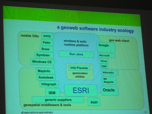
What is interesting here?Open mapping services allow you to import standard maps into Google Maps — detailed in new book called Google Map Hacks by O’Reilly.

an open software ecology

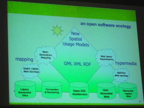
What is interesting here? There’s a software ecology and an industry ecology and a bit of confusion amongst them. Or maybe it’s that the two “ecologies” don’t overlap in that the industry ecology does not open up their platforms to the software ecology. Walled garden problem.

geospatial policies

* contextual privacy
* freely accessible geolocation APIs
* public geodata services

What is interesting here? Interesting practices for creating geodata; individuals, local groups, creating their own maps through grassroot means, and spunky, hacky techniques such as walking/riding with GPSs. Same sort of way that NAVTEQ does, only open. Also, Institute for Applied Autonomy’s iSee.

Geodata Search

* clearinghouses
* gateways
* repositories
* namespaces
* geoweb servers

Integrated GIS Web Hypermedia / Realtime Cubit Cartography

Usage: Computational Grids

* health mapping
** epidemiological + environmental maps
** health resources
** risky places
** people at risk
* security
* Geo Demographics
** microzone advertising
* at-risk ecologies
** eco-tourism
** green mapping
** indigenous mapping
* path-making (capturing folkloric knowledge of a place)
* pixel views: fragmenting places and spaces (micro views into a farm field)
* ground truth: empowering people in place (creating your own community information and stories in place)

Technorati Tags: , ,

Candidate ISEA2006 Interactive City Projects

Marc got me thinking about possibly inserting a project into the ISEA2006 Interactive City event. This came up during responses to the talk I gave at the Art Center Nabi Workshop on Urban Play and Locative Media, which I blogged about herein.

Possible projects I thought about are mostly revivals of previous work that didn’t get played out as fully as I would’ve liked. For instance:

WiFiKu which I did for the psy.geo.conflux even in New York City in May of 2004. Perhaps do that and really make a printable beautiful gorgeous map.

WiFiKu

The WiFiKu project was a bit of a “war walk” gathering the names of WiFi nodes and turning those into Americanized Haiku. The idea was that neighborhoods would be represented by the WiFiKu formed by the names of their local nodes. Whacky idea, but it was fun for the kinesthetic and “workshop” aspect — I took tours of people around and talked about WiFi usage, about Psychogeographic mapping and so on. It was less about really making a fool-proof map showing where nodes were and whether they were open or not. Instead, I intended to transform the invisible semantic layer hovering in the ether into a representation of the ‘hood.

ephemera_catalog

Ephemera Cache, which is an application for the WiFiBedouin which I also did then, but which I think could be more effective if it were distributed on a large scale during a large event in which there will undoubtedly be lots of WiFi-laptop-toting alpha geeks.

Why do I blog this? I’m trying to think of a way to add to some of the projects I felt I started but maybe thought I had finished while back in New York City. And Marc reminding me about Ephemera Cache, which I often forget about, got me going through the catalog to see what could be remastered, perhaps in a context that would be thick with participants, as I suspect ISEA2006 will be.

Technorati Tags: , , ,