It is rewarding to see some our areas of investigation at Lift Lab burgeoning in relation with our clients and partners. For instance, we now have a good set of tools and reasonably well-documented processes that help qualify and profile territories from their network activity (e.g. GSM, WiFi, Bluetooth, mobility infrastructures, social networks). One specificity of our approach is to produce visualizations that characterize the data at hand very early in the analysis process. It tremendously helps bring the different actors of a project on the same page by opening a dialogue and their interpretations of what they see is often great material for early insights to focus the investigation (see Exploration and engage in the discussion in the Data City essay).
This ability to sketch with data is particularly fruitful when dealing with multidisciplinarity. Indeed, data visualization brings together over a same language very diverse practices and methodologies (e.g. in our projects on network data, we deal with a bestiary of physicists, network engineers, marketing directors, salesmen, architects, geographers, social scientists, innovation specialists, …). Over the last months, we have been very fortunate to partner with our friends at Bestiario who share a common vision : data visualization is part of an innovation process not its outcome. They applied this perspective in their latest product Impure, an engine with an intuitive visual programming language. Impure has particularly revolutionized our ability to quickly communicate the early results our investigation. In a few weeks we have been able to swiftly create interfaces in collaboration with designers that did not have prior programming skill. One outcome of the use of our set of tools is Elephant Path, a concept by Lift Lab, designed and implemented by the young designer Olivier Plante in Impure :
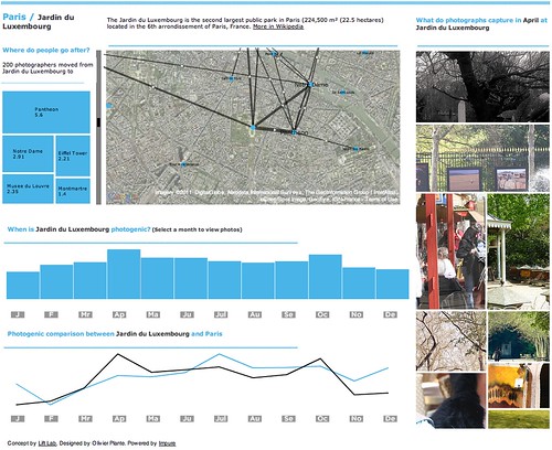
Elephant Path, a social navigation interface based on he thousand of pieces of information inhabitants and visitors share publicly on the web
Our idea of Elephant Path germinated years ago with the emergence of new ways of reading and discovering a territory through its digital activities (see my PhD thesis). It collided with our long interest in the principles of social navigation (see rss4you developed by Nicolas and Robi in the early days of content syndication) that leverage traces of activities with the goal to facilitate locating and evaluating information. In the physical world, a classic example of social navigation is a trail (called elephant path, desire line, social trail or desire path) developed by erosion caused by people making their own shortcuts (a phenomenon we like to observe).
Taking that concept into the informational layers of our cities and regions, we sketched in Impure the possibility to reveal unofficial routes and beaten tracks through the thousand of pieces of information inhabitants and visitors share publicly on the web. Technically, we deployed our own algorithms to extract travel sequences using collections of user-generated content from Wikipedia, Flickr and Geonames. For each region, Elephant Path lists Wikipedia entries and selects some of the monuments, parks, and other popular sites with a story. It consolidates the the Wikipedia entries with geographical coordinates via the Geonames API. Then, it uses the Flickr API to collect the information photographers share at these locations. Finally is applies our own network data analysis algorithms to filter the data, produce travel sequences and measure photogenic levels.
We have done it for both Paris and Barcelona. For each city, Elephant Path provides measures on the main trails, on the photogenic attractions and the months of activity. For instance the information reveals that:

Paris seems to be a “summer” destination according to their monthly photographic activity. If you are in Paris during that period, the parks (Bois de Boulogne, Parc Monceau and Jardin du Luxembourg) might not be you visiting priorities. Indeed, these sites seem to be more photogenic in Spring and Fall. But if you are at Jardin du Luxembourg, there is some chances that you were in the St-Germain des Prés neighborhood (e.g. Café de Flore) previously and that your stroll there might very well bring you to Centre Pompidou that links the nearby Panthéon with the trendy Marais neighborhood. Barcelona seems to be more of “fall” destination according to the monthly photographic activity. Discover it yourself. [More screenshots]
An interface designed for you to copy and adapt it
But Elephant Path doesn’t end with data visualization, maps and graphs that can be embedded into web pages. It is meant to be open and be appropriated in unexpected ways. The Impure platform offers numerous data access, information processing and visualization capabilities. You can copy the code and data of Elephant Path and improve it in your workspace. Content of the work content is under the terms of a Creative Commons License. Do not hesitate in ripping and adapting it!
