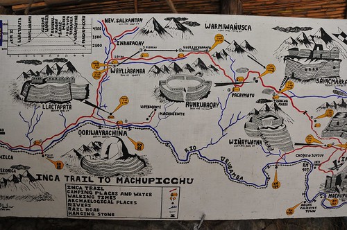
This photograph is my second “Truman Show” moment, near the end of day four of walking the Inca Trail, with this bit of exposed infrastructure along the seam where mountain meets trail. An abrupt reminder that the trail is maintained in the contemporary sense, pretty much exclusively for visitors using it as I was — to have a nice if a bit grueling four day trek through the Andes. (Likely this bit of electrical plumbing ran power and communications between a restaurant/lodge a few kilometers from the final “Sun Gate” milestone.)
The trail was presumed built by order of an Inca back in the day to allow for a proper system of communicating messages as well as goods. It connected all of the villages throughout the Empire, which extended throughout what is now Peru, as well as today’s Bolivia, Ecuador, Chile and Argentina.
It’s often described as a road system, but the Near Future Laboratory can only grok it as a larger system of communication very much like today’s Internet, mostly because of the mechanics of its formal protocols. It was not just something for one to walk along to get from point A to point B. It’s possible to speculate that it was built as a way of adhering social / power relations, creating an assemblage that included royal (the Inca King) control through messaging, maintaining control over borders, dispersing warriors and their power, transporting food, routing vital water along its intricate right-of-way. The protocol allowed for a system of runners operating in relay moving impossibly fast along the trail.
Every four years a race is held, running the trail from kilometer 82 to Machu Picchu, about 45 kilometers total. The current record time? 3 hours and 12 minutes. Today, it’s traveled by at most 500 people a day so that, for the typical 4 day trek, you’re on the trail with 2000 other people. (Only near the beginning at kilometer 82 did it appear to be bustling. Along the way, it was only occasionally that we ran into other people.)
Related:
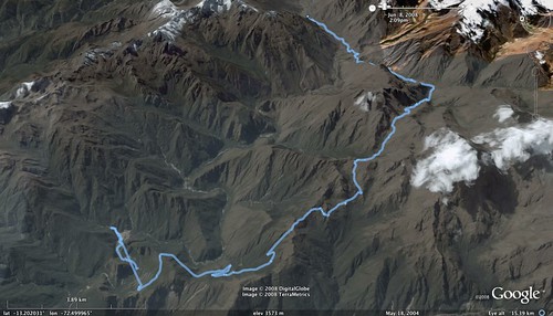
A Google Earth KML file of the trek, recorded along the way with a GPS device.


