Quiet But Not Quiescent

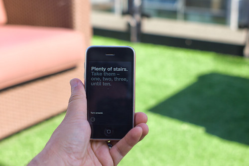
Judge not the less yammer-y state of the studio blog to indicate that there is nothing worth yammering about. It’s just that the clang of steel caressing code has been going on and that in great measure, too. Some of you may have glimpsed and grinned at the fantastic electronified edition of the paper Drift Deck that we developed a couple of years ago. That’s right. We’ve added *batteries to the Drift Deck and it’s fallen into the *app well..it’s an app which is fantastic because it means the last remaining physical card editions can become properly *artisinal and the electronic battery editions can spread the sensibility of the Drift Deck concept to the rest of the world.

Release is imminent. Prepare ye iPhones. Hop expectantly from foot-to-foot. More news in a short while, including linkages to downloadables. In the meantime, check out the new Drift Deck webified “page” and the fantastic roster of hammererers that batteryified the ‘deck.

..And then — onto the next thing here. It’ll be quiet a little, but good things are baking in the kiln, rest assured.

*Willow next. The superlative friendregator for the discerning social being.
Continue reading Quiet But Not Quiescent

Hand Drawn Maps..Drawn By Computer

ours

One of a sample of “Destination Maps” presented at SIGGRAPH Asia 2010 by a team of researchers. It shows a computer-generated emulation of the canonical napkin-style hand-drawn map. The described advantages are that it highlights relevant “neighborhood” streets and diminishes the arterials and highways that are not necessary and perhaps confusing for reaching the destination. It closes in on that typical style of map that was perhaps described best in Denis Wood’s “The Power of Maps” — the rough, perhaps off-scale map that gives the contours of a place and only what is roughly right and nearly necessary to navigate a place.

Some questions around this sort of map making:

* Why the use of kitsch-y napkin texture and the recognizable human-hand-hunting for lines with pencil? This idea of having the computer draw like a human seems a little dishonest, which puts me off. But, I suppose at the same time its recognizable and legible to people, which may make it more palatable and familiar, which I guess is something kitch is good at.

* I’m sure this is in the category of “it’s a prototype, relax” sort of thing, but shouldn’t the interstate highway signs be roughly-right, too?

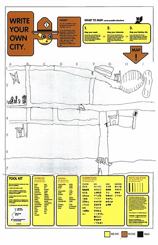
Related, just to keep the project in-mind, to the PDPal efforts to make roughly-right emotionally evocative personal maps — here’s one that was just the other day done by a friend’s young’n, by happy coincidence. I often think about this project and its relevance to what I still think is curious, intriguing and worth pondering over. Fascination with maps and cartography — mostly off-kilter, peculiar, provocative ways of making maps and exploring is super interesting to us here, especially the fellas smoothing parchment in the clean room on the 3rd floor.

JonseyPDPalMap-08102010

cf. Mark Shepherd’s Serendipitor — an iPhone app to help you explore by creating unexpected routes from point A to point B. I’ve been mucking with this for a few weeks — very cool and fun. Not for anyone trying to just get from A to B, which isn’t always the most exciting way to explore.

cf. Designing for iPad, which has some nice remarks on the use of kitsch in interface design.

via http://johanneskopf.de/publications/destination_maps/index.html
Continue reading Hand Drawn Maps..Drawn By Computer

William H. Whyte Revisited: An Experiment With An Apparatus for Capturing Other Points of View

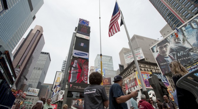
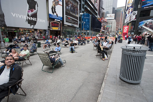
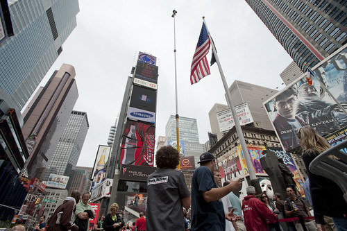
Times Square Urban Living Room from Julian Bleecker. More Apparatus Videos.

[[Update: The Apparatus was exhibited at the HABITAR show at LABoral in Gijón Spain this summer 2010.]]

A couple of months ago a colleague, Jan Chipchase, floated by my desk and handed me a book of his called “The Social Life of Small Urban Spaces” by William H. Whyte. I had no idea who this Whyte character was and I could only guess what it was about and, just by the title — I figured this would lead me down another rabbit’s hole of exploration and experimentation.

As I flipped through the pages, looking at the images of urban observations of New York City from the 1970s, I was enthralled by the technique as well as the substance of the material. Whyte and his team were capturing the intriguing, sometimes curious ways in which people adapt small corners of urban space and their habits and practices and rituals. The pace and momentum of pedestrian movement is intriguing. Without assuming anything in particular, Whyte’s work was capturing movement in a seductive way — even small scale jolts and shifts and gestures. Someone moving a chair just a small bit to indicate that he is not attempting to invade someone’s microlocal private space. You see the “fast-movers” bobbing and weaving quickly around a phalanx of slow moving tourists, window shoppers or a more elderly pedestrian.

Wonderful, intriguing stuff. Sold. Hooked. What’s the brief? Oh, what would I do? Follow footsteps and curiosities, I guess. I was curious — how can the momentum and pace and speed (or lack thereof) of the urban flows be captured, highlighted, brought into focus and revealed in such a way as to visually describe time, movement, pace, scales of speed and degrees of slowness?

There is lots to say about Whyte, I am sure. I have only begun to scratch the surface of this well-known urban sociologist, explorer, scout, observer. But, for the purposes here what happened as a result of this brief conversation with Jan was something that spread through the studio — a bout of curiosity that led to another, other project. It started simply by wondering if the observational studies that Whyte had done both in this book and in other projects could be done today? And, if so — what might they observe? What might be the questions? By what principles and assumption would small urban spaces be explored?

A copy of the films Whyte had made was secured in short order. Simple observations from ground level as well as from carefully chosen vantage points up high, above the ground. This intrigued me. There had been a project in the studio this time last year with things placed high for observational purposes (high chairs, periscopes, etc.) and it was filed away in the “lost projects” binder, so this seemed perhaps a way to revive that thinking. Over the course of a week, I made four trips to Home Depot, Simon jigged a prototype bracket on the CNC machine, and I had a retractable 36 foot pole that I imagined I was going to hang a heavy DSLR off of — it scared the bejeezus out of me and required two people to safely raise up. Too high, too floppy.

Another pole — 24 feet. Daunting but serviceable. It retracts to 8 feet, which is still quite high, but the range made it worth the embarrassment. After a brief bang around the reputation and suggestion networks, a wide field of view camera was identified and two ordered. Two cameras, secured to the pole produced a fair resolution, very wide field of view for displaced observations from a peculiar point of view. Good enough.

Penn Station Still Observation from Julian Bleecker on Vimeo.

Observation apparatus deployed at 7th Avenue main entrance to Pennsylvania Station, NYC, capturing ingress & egress flows, pedestrians waiting, deciding, waking up in the morning upon hitting the sidewalk, &c. The slow-scan mode highlights things which are not moving and therefore often discounted as to their import such as, for instance, the two peculiar characters to the far left who scarcely move (and were still there at the end of the day, around 7pm!), defensible space obstacles in the form of potted plants, people who wait for things, time to pass, people or taxi cabs, &c.
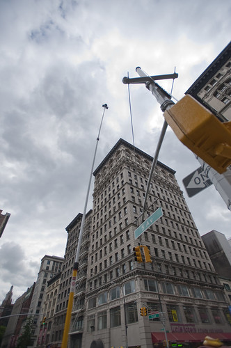
A notion interpreted and brought into focus by Rhys Newman.

Friday June 19, 16.17.17

15th Street and 5th Avenue, New York City.

Using some generative algorithms to show neutral zones of flow and highlighting areas of relatively stable inactivity. Somewhat mitigated by the windiness of the day which caused the cameras to move quite a bit.

Whyte was intrigued by the movement, flows, behaviors, but also emphasized the engaged observations — pen and paper, not just measurements and statistics. He was observing and analyzing both statistically — flows of people per time period over various widths of sidewalk, for example — as well capturing those things that one misses in abstracted data sets. In the film, his avuncular tone draws our attention to small curious practices. Things like someone to moving a chair in a public open space barely a few feet from where it was so as to indicate to a nearby fellow New Yorker that they were not intending to impose upon their public-privacy.

There was something about these sorts of couplings between the analytic data — numbers and so forth — and the observed, seen and demonstrated activities of people. Observed practices crafted into a kind of story about this subject — the social life of small urban spaces. Finding ways to observe and perhaps produce useful insights and design inspirations based on the observations seems a reasonable goal. There is only so much you can do with the books of abstracted data squirreled away some place before you have to go out in the world. Where I was most interested in exploring was somewhere “lower” than the high-level observations which produce intriguing visualizations but are many steps removed from the everyday, quotidian practices. Some empirical, rough-around-the-edges, observational data ethnography. A close cousin of the truly fascinating data visualizations we have grown to love. Perhaps close to Fabien’s notion of citizen sensors and citizen cartography.

We got plenty of guff with the Apparatus when we took it on the new Highline Park. One rather abrupt park minder — sort of behaving like an airline stewardess on a really bad day — was not pleased with the pole at all and let us know it. I had to talk to someone back at the offices of the "Friends of The Highline" via a cellphone given to me by a guy who was like a human surveillance entity. The woman on the phone explained – after listening to my perhaps overly analytic and historic description of the project, Whyte, &c. – that they do not allow tripods or, "you know..long poles" in the park.

Errr ahhh…

It was all very weird, and very un-appealing and put a cloud on what is a playful project, I think, but — *shrug*.

It’s all to be figured out. Or not. Perhaps its just observation. Scraps and visual thinking. Some notes in video. Constructed objects and anticipation of going mobile in Seoul and Helsinki and Linz and London. &c. Or some kind of exploration to suggest alternative ways of seeing the world around us. That may be closer to the point, at least now.

The post-processing stages of the activity are mostly explorations of ways in which individuals or small groups of people in movement could become their own producers of representations of what they do, in an aesthetic sense. What other sorts of systems might people-flows evoke or be reminiscent of? Weather patterns? Displacement grids? Where is there stillness in the bustle? Can the city’s flows be slowed down to evoke new considerations and new perspectives of what happens in the small urban spaces?

People themselves are often seen to be controlled in a top down fashion — even less insidious than “the man”, I think of the significant pedestrian operator — the “I want to cross” button at many busy intersections. It’s a point of contact with the city’s system of algorithmic, synchronized flows. But what about people as their own algorithms, by virtue of their occupancy of urban space? Not following specific top-down plans, but bottom up actions and movements. Not augmented reality but productions of realities. The center of what happens, displaced from the operational command center that articulates how the flows will operate.

I love these moments that countervene the system-wide control grids, which you can see if you watch carefully the raw footage from 15th Street and 5th Avenue where pedestrians spread themselves into the street, stretching the boundaries of the safety of the sidewalk in anticipation of the crossing. Or, perhaps something I love less but it is still something to note, a bicyclist turning the corner against traffic, possibly into pedestrians who may be less inclined to look from whence traffic should not be coming.

We push buttons to control the algorithms of the city, as in the buttons to control signals and so forth. Or roll our cars over induction loops – these are parameters to the algoithms of top-down controls over urban flows. Suppose we interceded more directly or suppose the geometry of the city were represented this way, as a product of the non-codified “algorithm” of movements.

What sort of world would this be? What would it look like?

Highlighting only things that are moving in the Union Square Farmers’ Market.

A cartesian grid distorted by flows around the Union Square Farmers Market.

Wednesday June 17, 15.04.24

Wednesday June 17, 14.44.17

Help thanks to Marcus Bleecker, Chris Woebken, Rhys Newman, Simon James, Jan Chipchase, Aaron Meyers, Noah Keating, Bella Chu, Duncan Burns, Andrew Gartrell, Nikolaj Bestle. And so on.

Videos live online and will accumulate over time. This is Times Square, NYC, Highline in Chelsea NYC, and a generative video done with Max/MSP Jitter

Conflux Festival 2009 Call Proposals

11092008_162058_18

Conflux is having their 6th annual Conflux Festival! The deadline for submissions is soon — August 15th. At last year’s Conflux we brought our “Drift Deck” technology and had a swell time! Several years back, we did WiFiKu — we walked the streets of New York City neighborhoods and digitally scanning for the names of WiFi “Hot Spots” (Hot Spots…how quaint) and constructed a visual map containing Haiku from these found names. That was back when wireless networks were not as quotidian as they are today and we were all trying to make sense of this new puff of network leaking out into the streets. This year — who knows?

CONFLUX FESTIVAL 2009
CONFLUXCITY CALL FOR PROPOSALS
http://confluxfestival.org/

Conflux, the art and technology festival for the creative exploration of urban public space, is pleased to announce the 6th annual Conflux Festival will take place from September 17-20, 2009 and will be hosted by New York University.

In keeping with its commitment to urban artistic exploration, community participation, shared knowledge, and critical civic engagement, Conflux will organize a user-generated open format event on Sunday September 20th, 2009 from 10am-6pm.

Through an open submissions process, ConfluxCity will provide a platform for artists, urban geographers, technologists and others to organize and produce innovative activities dedicated to the examination, celebration and (re)construction of everyday urban life.

Drawing inspiration from Burning Man’s creed of radical self-reliance and BarCamp’s philosophy of openness and participation, ConfluxCity will adopt an open-space approach in which participants will be expected to organize, promote, and host their own activities and events. To facilitate this format, the Conflux Festival headquarters and website will serve as a central communications hub directing festival attendees outward to individual event websites and locations.

To submit a proposal to participate in the festival, please see the submission guidelines at the Conflux Festival website: http://confluxfestival.org/2009/submit-a-project/.

The deadline for submissions is August 15, 2009.

http://confluxfestival.org/

GPX to DXF – Drawing GPS Tracks

Sunday March 29, 13.25.20

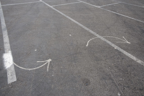
Lines and arrows and splines point the way. Taken in a parking lot near the beaches at Santa Monica.

It has not been a quiet couple of days here in the Laboratory. Lots of gear and glassware about. Goggles, bunsen burners and all that sort of thing. And the report draft was just finished with Nicolas Nova, which occupied many early mornings. We almost spilled an organic, but toxic material on the draft which cause a collective gasp, but it was pulled out of the way, just in time before irrevocable damage was done. We’re writing with ink and pen these days, which feels so much more angelic and respectful, but are, through incidents like this, reminded that such may have nostalgic integrity, but it is also quite delicate and precious.

In the midst of all that was the need to translate a GPS track from GPX format to DXF. This was harder than I thought it would be, at least after poking around the Google. There are some tools that’ll do format conversions and so forth, but they were way more expensive than I thought was reasonable, seeing as we’re not making precious objects. It’s basically a translation of one connected graph format to another.

Okay, so — it was time to think about making our own tools, which took 10 times less time than the original set of Google searches, mostly because of the recently discovered ancient treasure of a Java library our buddy Tom Carden wrote back in the Precambian of the Age of the Network — somewhere’s around 1996 or some such…

This library provides enough functionality to read a GPX track and draw it on screen. The Processing.org DXF library can spit that drawing from the screen out as a saved DXF. So, that basically solves the problem. The DXF files that come out are flat lines that can then be serviced by other software to do other things. (There also exists this Kabeja library for consuming DXF and creating DOM models, which we’ll save for another day.

My lead toward the Carden code was found here on the Processing.org forums, where I found enough of a simple code snippet to get me out and through the chiseled hole in the brick wall I had hit.

Also to note is the small comment in the small simple bit of code that can cobble together many separate GPX files (tracks from a GPS) into one larger one, which can be quite convenient.

Why do I blog this? Mostly for my own recollection and notes as to how things are done. It’s been enough time in the jungle of small, utility challenges that, when on another project inevitably in the future, some small task I need to perform smells familiar — but, why? One gets the feeling — I’ve had to do this before? What project was it? How did I do it? Playing in the geo/map-making/cartography space has all these little formats and translation steps that are a bit zany to wrangle. Jotting a post with a bit of a reminder helps. Te bigger “why do I blog this?” has to do with using real-world GPS tracks as a basis for constructing other things — the input is movement in the world, an effort to figure out how a map might look that inverted the assumptions about static geographies and fluid movement, so that the ground moved and the things that moved became static. *shrug*


import processing.dxf.*;

// Based on Tom Carden's code and GPX library available at
// http://www.processing.org/hacks/hacks:gpx
// Press "R" and your track gets saved as a DXF file which
// you can use in lots of other things..

import tomc.gpx.*;

GPX gpx;

GPXTrack track;
GPXTrackSeg trackSeg;
String trackName;

double minLat, maxLat;
double minLon, maxLon;
double minEle, maxEle;
boolean record = false;

final static int SEPARATOR = 200;
String filename, filepath;

// I collapse lots of individual GPX files into one larger file
// using the free gpsbabel.
// At the command prompt (the GUI editions don't have enough features
// to do this) you'll do something like this:

/************

/Applications/GPSBabel+-1.3.5/gpsbabel -i gpx -f 20090321.gpx 
-f 20090401.gpx -f 20090402.gpx -f 20090403.gpx 
  -x transform,wpt=trk,del 
  -x radius,distance=5,lat=34.0236,lon=-118.4319,nosort 
  -x transform,trk=wpt,del  
  -o gpx -F foo.gpx

The "-x" filters do a couple of things.
The first -x filter turns the tracks into waypoints to work around
an issue that gpsbabel has with the "radius" filter
The second -x filters the output only to points that are within a
5 mile radius of the specified lat/lon, which is useful if you want
to limit the range of data you draw.
The final -x filter turns the waypoints back into tracks, which is what we want
Finally, we output as GPX formatted data and
write the whole thing to the file called foo.gpx.dxf


*************/

void setup()
{
  // Yep, hardcoded path to the GPX file we'll process
  filepath = "/Users/julian/Desktop/GPS Tracks/foo.gpx";
  // We'll use the name of the file for our DXF output, with the ".dxf" extension added
  filename = (new File(filepath)).getName();
  size(800, 800, P2D);
  gpx = new GPX(this);

  // you can load a file or a URL evidently..
  gpx.parse(filepath);

  // Find scope of track file so we can scale our drawing
  minLat = 2000; minLon = 2000; minEle = 100000;
  maxLon = -1000; maxLat = -1000;

  println("track count "+gpx.getTrackCount());
  for(int j=0; j < gpx.getTrackCount(); j++) {
  track = gpx.getTrack(j);
  println("track size "+track.size());
  for(int k=0; k<track.size(); k++) {
     trackSeg = track.getTrackSeg(k);
     println("track seg size "+trackSeg.size());
  for (int i = 0; i < trackSeg.size(); i++)
  {

    GPXPoint pt = trackSeg.getPoint(i);
    if (pt.lat < minLat)
    {
      minLat = pt.lat;
    }
    if (pt.lon < minLon)
    {
      minLon = pt.lon;
    }
    if (pt.ele  maxLat)
    {
      maxLat = pt.lat;
    }
    if (pt.lon > maxLon)
    {
      maxLon = pt.lon;
    }
    if (pt.ele > maxEle)
    {
      maxEle = pt.ele;
    }
  }
  }
  }
println("Lat: " + minLat + " to " + maxLat);
println("Lon: " + minLon + " to " + maxLon);
println("Ele: " + minEle + " to " + maxEle);
}

boolean hasDrawn = false;

void draw()
{
  if(record == true) {
    beginRaw(DXF, filename+".dxf");
    hasDrawn = false;
  }
  if(hasDrawn == false) {
  background(255);
  //stroke(#FF0000);
  //line(0, SEPARATOR, width, SEPARATOR);

  double distance = 0;

 for(int j=0; j < gpx.getTrackCount(); j++) {
  track = gpx.getTrack(j);
  //println("track size "+track.size());
  for(int k=0; k<track.size(); k++) {
     trackSeg = track.getTrackSeg(k);
     //println("track seg size "+trackSeg.size());
       GPXPoint prevPt = trackSeg.getPoint(0);
      PVector prevPos = GetPosition(prevPt);
      for (int i = 1; i < trackSeg.size(); i++)
      {
       GPXPoint pt = trackSeg.getPoint(i);

    // Show track
    PVector pos = GetPosition(pt);
    stroke(#FF8800);
    line(prevPos.x, prevPos.y, pos.x, pos.y);
    prevPos = pos;
  }
  }
 }
  }
  if(record == true) {
    endRaw();
    record = false; // stop recording to the file
    println("done writing "+filename+".dxf");
  }
  hasDrawn = true;
}

void keyPressed() {
  if (key == 'R' || key == 'r') {
    record = true;
  }
}

PVector GetElevation(int n, GPXPoint pt)
{
  return new PVector(
      map(n, 0, trackSeg.size(), 10, width - 10),
      map((float) pt.ele, (float) minEle, (float) maxEle, SEPARATOR - 10, 10)
  );
}

PVector GetPosition(GPXPoint pt)
{
  return new PVector(
      map((float) pt.lon, (float) minLon, (float) maxLon, 10, width - 10),
      map((float) pt.lat, (float) minLat, (float) maxLat, SEPARATOR + 10, height - 10)
  );
}

Embodied Viewing Platforms

Here and There a cartographic experiment by Shulze and Webb.

I think I figured out why I enjoy this map by Jack Schulze and Matt Webb — it can possibly induce vertigo, which means it’s human, real and embodied. The rolling coasting perspective that deliberately distorts the island of Manhattan shows the city from a fixed point of view, but still showing no horizon. The map is not these flat views that we’ve become so accustomed to, floating above the ground but yet firm, and sure and secure. A little more awkwardness in points-of-view is called for, I think.
Continue reading Embodied Viewing Platforms

Drift Deck (Analog Edition) Card Art

View SlideShare document or Upload your own. (tags: psychogeography cards)

The Drift Deck (Analog Edition) is an algorithmic puzzle game used to navigate city streets. A deck of cards is used as instructions that guide you as you drift about the city. Each card contains an object or situation, followed by a simple action. For example, a situation might be — you see a fire hydrant, or you come across a pigeon lady. The action is meant to be performed when the object is seen, or when you come across the described situation. For example — take a photograph, or make the next right turn. The cards also contain writerly extras, quotes and inspired words meant to supplement your wandering about the city.

More project details here.
Continue reading Drift Deck (Analog Edition) Card Art

Drift Deck

Drift Deck. For Conflux 2008, NYC
confluxfestival.org/conflux2008/.

For Analog Play (batteries not required.)

(Some production documentation above; click “Notes”.)

The Drift Deck (Analog Edition) is an algorithmic puzzle game used to navigate city streets. A deck of cards is used as instructions that guide you as you drift about the city. Each card contains an object or situation, followed by a simple action. For example, a situation might be — you see a fire hydrant, or you come across a pigeon lady. The action is meant to be performed when the object is seen, or when you come across the described situation. For example — take a photograph, or make the next right turn. The cards also contain writerly extras, quotes and inspired words meant to supplement your wandering about the city.

Processed in collaboration with Dawn Lozzi who did all of the graphic design and production.

For exhibition at the Conflux 2008 Festival, NYC, September 11-14, 2008, and hosted by Center for Architecture located at 536 LaGuardia Place, New York, NY 10012

The motivation for Drift Deck comes from the Situationist International, which was a small, international group of political and artistic agitators. Formed in 1957, the Situationist International was active in Europe through the 1960s and aspired to major social and political transformations.

Guy Debord, one of the major figures in the Situationist International, developed what he called the “Theory of the Dérive.”

“Dérives involve playful-constructive behavior and awareness of psychogeographical effects, and are thus quite different from the classic notions of journey or stroll.

In a dérive one or more persons during a certain period drop their relations, their work and leisure activities, and all their other usual motives for movement and action, and let themselves be drawn by the attractions of the terrain and the encounters they find there. Chance is a less important factor in this activity than one might think: from a dérive point of view cities have psychogeographical contours, with constant currents, fixed points and vortexes that strongly discourage entry into or exit from certain zones.”

Psychogeography was defined in 1955 by Guy Debord as the “the study of the precise laws and specific effects of the geographical environment, consciously organized or not, on the emotions and behavior of individuals.” Psychogeography includes just about anything that takes pedestrians off their predictable paths and jolts them into a new awareness of the urban landscape.” The dérive is considered by many to be one of the more important of these strategies to move one away from predictable behaviors and paths.

http://is.gd/1Gy1
http://en.wikipedia.org/wiki/Dérive
http://en.wikipedia.org/wiki/Psychogeography

The cards will be available for festival visitors to borrow and return for others to use during the Conflux Festival.

Design and Implications by Julian Bleecker and Dawn Lozzi. Creative Assistance and Support from Nicolas Nova, Pascal Wever, Andrew Gartrell, Simon James, Bella Chu, Pawena Thimaporn, Duncan Burns, Raphael Grignani, Rhys Newman, Tom Arbisi, Mike Kruzeniski and Rob Bellm. Processed for Conflux Festival 2008.

Special Joker Cards featuring compositions by Jane Pinckard, Ben Cerveny, Jane McGonigal, Bruce Sterling, Katie Salen, Ian Bogost and Kevin Slavin. Joker illustrations by Rob Bellm.

Original Proposal

www.nearfuturelaboratory.com/projects/drift-deck/

Part of a long, proud line of land mapping technologies that includes PDPal, Ubicam Backward Facing Camera and Battleship: Google Earth, and WiFiKu.

Continue reading Drift Deck

iPhone for Hertzian Space

Architecture is the simplest means of articulating time and space, of modulating reality and engendering dreams…The architecture of tomorrow will be a means of modifying present conceptions of time and space. It will be both a means of knowledge and a means of action. Architectural complexes will be modifiable. Their appearance will change totally or partially in accordance with the will of their inhabitants.

Formulary for a New Urbanism, Ivan Chtcheglov, 1953, from Situationist International Anthology, Ken Knabb editor.

I’m no theorist of space, architecture, and digital media — there are plenty of bright ones about. What I’m curious about are the material choices available to the design and construction of spaces that are modifiable by their inhabitants. What are the ways that time and space — the key elements for bounding and warping habitats — will be “architected” by the time and location-based activities of digital devices?

"Locative Media" is the term that was (once) used to describe media that is digitally marked with some location correlation. In the most primordial example, a photograph is inscribed with the location from where it was taken. Now, we see these sorts of weak-signals leaking into all kinds of (somewhat anticipated, eagerly accepted) “tagging” of many new and curious forms of digital-social expression. What does it mean to find out that someone is Twittering near me? Continue reading iPhone for Hertzian Space

High Chair

High Chair is a tall chair placed on or near the sidewalk allowing sitters a chance to see the city from nearly above. It’s a middle vantage point, above the street, below the skyscraper, with a full view that balconies seldom offer, and still amongst the pedestrian fray. The chair is evocative of that used by a line judge at a tennis match, or a lifeguard’s chair found at the beach. It is approximately 3 meters high as measured from the ground to the seat bottom, light and sturdy to allow it to be easily moved. Integrated into the leg work is a simple ladder for ascent. The chair is wide enough to allow two people to sit comfortably and enjoy the view together.
The chair is meant to be a playful, curious object that disrupts the conventions of the bustling city sidewalk. It allows visitors to spend a moment watching pedestrians from slightly above. It’s a middle vantage point, above the street, below 1st story fire escapes. It’s unlike the view provided by Apple Tours double-decker in that it is still pedestrian, in a way, and engaged in the bustle below.
We plan on pre-fabricating most of the chair and constructing it on-site. While our plans are still preliminary, there are certain considerations that are relevant. Firstly, the chair is expected to be mobile so that it can be shuttled to various locations, or easily moved to avoid hassles with retailers or law enforcement.
(For Conflux 2008 with Pascal Wever, Rhys Newman, Raphael Grignani, Duncan Burns, Julian Bleecker. Drawings: Rhys Newman)