The Week Ending 291210

2=8.41 1=11.40

Rules, instructions, parameters? Embedded inscriptions of some nature, found on a wall in Sayulita Mexico.

Well, maybe weeknotes are from the *week ending* but posted at the *week commencing*. One advantage of being one’s own blog boss, I suppose.

It was a decidedly *quick* week for some reason — perhaps because the Laboratory’s brother was visiting these last couple and action, thinking and events seem to accelerate the time. There was plenty of discussions of stories and filmmaking, which ties nicely into what *must* happen this month: the re-making of several short (30 seconds or so) of this visual design fiction stories meant to communicate some of our principles of Trust as embodied in some props/prototypes. This proves quite creatively engaging and challenging.

There was a pleasant slaloming conversations with the curious and effervescent Natalie, discussing the Latourian design sensibilities and the ways that debates and conversations embed themselves with artefacts. It was lovely to have this chat, if only to begin trying out the various *props* that we’ve been making that are exemplars themselves of these arguments/theories/perspectives. The question remains — what is new here, as an argument? It was encouraging to here Natalie’s excitement and the geneology of this sort of thinking, reaching back to here canonical Live Wire and Rich Gold’s Evocative Knowledge Objects (to which the Theory Object owes everything.)

This decanted into thoughts on a Latour essay presently at desk side.

The third connotation of the word design that seems to me so significant is that when analyzing the design of some artefact the task is unquestionably about meaning — be it symbolic, commercial, or otherwise. Design lends itself to interpretation; it is made to be interpreted in the language of signs. In design, there is alwas as the French say, un dessein, or in Italian, designo. To be sure, in its weakest form design added only superficial meaning to what was brute matter and efficiency. But as it infiltrated into more and more levels of the objets, it carried with it a new attention to meaning.

[[A Cautious Prometheus? A Few Steps Toward a Philosophy of Design (with Special Attention to Peter Sloterjdijk. Bruno Latour]]

[[And special sideways inspiration from Karen, whose present reading/thinking I seem to be accidentally following alongside.]]

And then, I was thinking about Trust in this context and this precise basis for the process of *embedding* the sensibilities and sensitivities of Trust as a design practice. More as this idea develops.

There was a round of planning for future projects at the Nokia Design Strategic Projects studio, which meant thinking about what from Trust moves forward and in which ways and by what means. Similarly, we are beginning to share Trust. And wondering — to whom and to what ends? I am intrigued by this — how do you circulate ideas and with what goals so you know — in a more actionable way — how the ideas materialize and create other goals, especially within such a byzantine organization. This, I think, is one of the larger 2010 *professional* goals, I suppose (seeing as I have not really captured what those might be yet — bit tardy on that objective — I like to have New Year’s goals rather than New Year’s resolutions) — how to communicate ideas such as these, do so without PowerPoint and do so in such a way that you snap people out of a corporate stupor, or whatever it is — and do more than just scrape a bit of paint on the battleship. Rather, help set a different course heading.

William H. Whyte Revisited: An Experiment With An Apparatus for Capturing Other Points of View

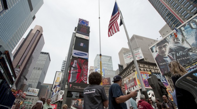
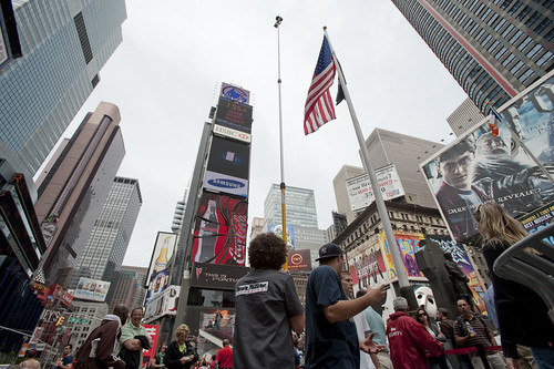
Times Square Urban Living Room from Julian Bleecker. More Apparatus Videos.

[[Update: The Apparatus was exhibited at the HABITAR show at LABoral in Gijón Spain this summer 2010.]]

A couple of months ago a colleague, Jan Chipchase, floated by my desk and handed me a book of his called “The Social Life of Small Urban Spaces” by William H. Whyte. I had no idea who this Whyte character was and I could only guess what it was about and, just by the title — I figured this would lead me down another rabbit’s hole of exploration and experimentation.

As I flipped through the pages, looking at the images of urban observations of New York City from the 1970s, I was enthralled by the technique as well as the substance of the material. Whyte and his team were capturing the intriguing, sometimes curious ways in which people adapt small corners of urban space and their habits and practices and rituals. The pace and momentum of pedestrian movement is intriguing. Without assuming anything in particular, Whyte’s work was capturing movement in a seductive way — even small scale jolts and shifts and gestures. Someone moving a chair just a small bit to indicate that he is not attempting to invade someone’s microlocal private space. You see the “fast-movers” bobbing and weaving quickly around a phalanx of slow moving tourists, window shoppers or a more elderly pedestrian.

Wonderful, intriguing stuff. Sold. Hooked. What’s the brief? Oh, what would I do? Follow footsteps and curiosities, I guess. I was curious — how can the momentum and pace and speed (or lack thereof) of the urban flows be captured, highlighted, brought into focus and revealed in such a way as to visually describe time, movement, pace, scales of speed and degrees of slowness?

There is lots to say about Whyte, I am sure. I have only begun to scratch the surface of this well-known urban sociologist, explorer, scout, observer. But, for the purposes here what happened as a result of this brief conversation with Jan was something that spread through the studio — a bout of curiosity that led to another, other project. It started simply by wondering if the observational studies that Whyte had done both in this book and in other projects could be done today? And, if so — what might they observe? What might be the questions? By what principles and assumption would small urban spaces be explored?

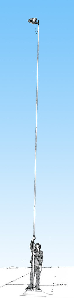
A copy of the films Whyte had made was secured in short order. Simple observations from ground level as well as from carefully chosen vantage points up high, above the ground. This intrigued me. There had been a project in the studio this time last year with things placed high for observational purposes (high chairs, periscopes, etc.) and it was filed away in the “lost projects” binder, so this seemed perhaps a way to revive that thinking. Over the course of a week, I made four trips to Home Depot, Simon jigged a prototype bracket on the CNC machine, and I had a retractable 36 foot pole that I imagined I was going to hang a heavy DSLR off of — it scared the bejeezus out of me and required two people to safely raise up. Too high, too floppy.

Another pole — 24 feet. Daunting but serviceable. It retracts to 8 feet, which is still quite high, but the range made it worth the embarrassment. After a brief bang around the reputation and suggestion networks, a wide field of view camera was identified and two ordered. Two cameras, secured to the pole produced a fair resolution, very wide field of view for displaced observations from a peculiar point of view. Good enough.

Penn Station Still Observation from Julian Bleecker on Vimeo.

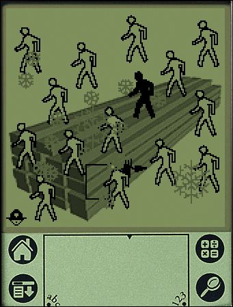
Observation apparatus deployed at 7th Avenue main entrance to Pennsylvania Station, NYC, capturing ingress & egress flows, pedestrians waiting, deciding, waking up in the morning upon hitting the sidewalk, &c. The slow-scan mode highlights things which are not moving and therefore often discounted as to their import such as, for instance, the two peculiar characters to the far left who scarcely move (and were still there at the end of the day, around 7pm!), defensible space obstacles in the form of potted plants, people who wait for things, time to pass, people or taxi cabs, &c.

A notion interpreted and brought into focus by Rhys Newman.

Friday June 19, 16.17.17

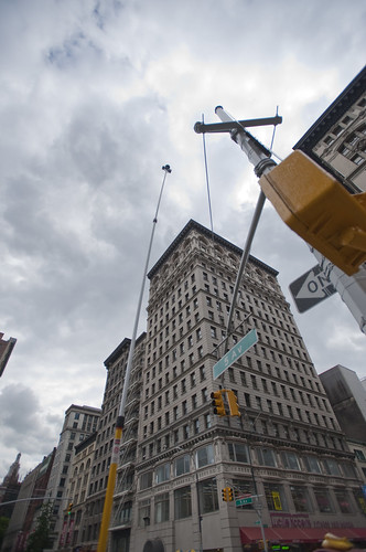
15th Street and 5th Avenue, New York City.

Using some generative algorithms to show neutral zones of flow and highlighting areas of relatively stable inactivity. Somewhat mitigated by the windiness of the day which caused the cameras to move quite a bit.

Whyte was intrigued by the movement, flows, behaviors, but also emphasized the engaged observations — pen and paper, not just measurements and statistics. He was observing and analyzing both statistically — flows of people per time period over various widths of sidewalk, for example — as well capturing those things that one misses in abstracted data sets. In the film, his avuncular tone draws our attention to small curious practices. Things like someone to moving a chair in a public open space barely a few feet from where it was so as to indicate to a nearby fellow New Yorker that they were not intending to impose upon their public-privacy.

There was something about these sorts of couplings between the analytic data — numbers and so forth — and the observed, seen and demonstrated activities of people. Observed practices crafted into a kind of story about this subject — the social life of small urban spaces. Finding ways to observe and perhaps produce useful insights and design inspirations based on the observations seems a reasonable goal. There is only so much you can do with the books of abstracted data squirreled away some place before you have to go out in the world. Where I was most interested in exploring was somewhere “lower” than the high-level observations which produce intriguing visualizations but are many steps removed from the everyday, quotidian practices. Some empirical, rough-around-the-edges, observational data ethnography. A close cousin of the truly fascinating data visualizations we have grown to love. Perhaps close to Fabien’s notion of citizen sensors and citizen cartography.

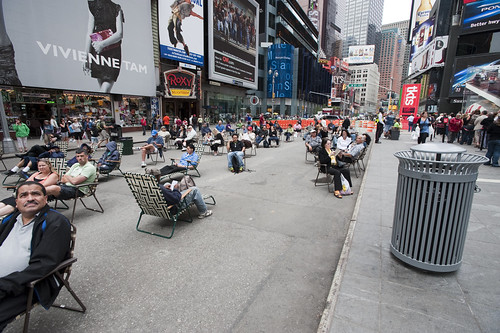
We got plenty of guff with the Apparatus when we took it on the new Highline Park. One rather abrupt park minder — sort of behaving like an airline stewardess on a really bad day — was not pleased with the pole at all and let us know it. I had to talk to someone back at the offices of the "Friends of The Highline" via a cellphone given to me by a guy who was like a human surveillance entity. The woman on the phone explained – after listening to my perhaps overly analytic and historic description of the project, Whyte, &c. – that they do not allow tripods or, "you know..long poles" in the park.

Errr ahhh…

It was all very weird, and very un-appealing and put a cloud on what is a playful project, I think, but — *shrug*.

It’s all to be figured out. Or not. Perhaps its just observation. Scraps and visual thinking. Some notes in video. Constructed objects and anticipation of going mobile in Seoul and Helsinki and Linz and London. &c. Or some kind of exploration to suggest alternative ways of seeing the world around us. That may be closer to the point, at least now.

The post-processing stages of the activity are mostly explorations of ways in which individuals or small groups of people in movement could become their own producers of representations of what they do, in an aesthetic sense. What other sorts of systems might people-flows evoke or be reminiscent of? Weather patterns? Displacement grids? Where is there stillness in the bustle? Can the city’s flows be slowed down to evoke new considerations and new perspectives of what happens in the small urban spaces?

People themselves are often seen to be controlled in a top down fashion — even less insidious than “the man”, I think of the significant pedestrian operator — the “I want to cross” button at many busy intersections. It’s a point of contact with the city’s system of algorithmic, synchronized flows. But what about people as their own algorithms, by virtue of their occupancy of urban space? Not following specific top-down plans, but bottom up actions and movements. Not augmented reality but productions of realities. The center of what happens, displaced from the operational command center that articulates how the flows will operate.

I love these moments that countervene the system-wide control grids, which you can see if you watch carefully the raw footage from 15th Street and 5th Avenue where pedestrians spread themselves into the street, stretching the boundaries of the safety of the sidewalk in anticipation of the crossing. Or, perhaps something I love less but it is still something to note, a bicyclist turning the corner against traffic, possibly into pedestrians who may be less inclined to look from whence traffic should not be coming.

We push buttons to control the algorithms of the city, as in the buttons to control signals and so forth. Or roll our cars over induction loops – these are parameters to the algoithms of top-down controls over urban flows. Suppose we interceded more directly or suppose the geometry of the city were represented this way, as a product of the non-codified “algorithm” of movements.

What sort of world would this be? What would it look like?

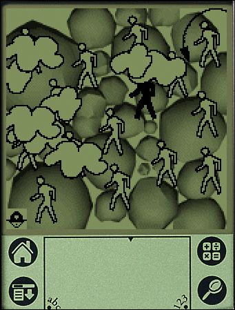
Highlighting only things that are moving in the Union Square Farmers’ Market.

A cartesian grid distorted by flows around the Union Square Farmers Market.

Wednesday June 17, 15.04.24

Wednesday June 17, 14.44.17

Help thanks to Marcus Bleecker, Chris Woebken, Rhys Newman, Simon James, Jan Chipchase, Aaron Meyers, Noah Keating, Bella Chu, Duncan Burns, Andrew Gartrell, Nikolaj Bestle. And so on.

Videos live online and will accumulate over time. This is Times Square, NYC, Highline in Chelsea NYC, and a generative video done with Max/MSP Jitter

Safety In A Ubicomp World

Timo et al Mediamatic have created a superb physical instantiation of safety in an era when the network leaks rather perniciously into the physical world. Their RFID safe enclosure protects your near-field communication objects from being scanned by faulty equipment or data muggers discretely consuming the swarms of RFID krill floating around most alpha tier urban centers. A lovely instantiation to help think through how people’s concerns around safety, security and trust always seem to leave opportunities for the always entrepreneurial accessories marketplace.

Well done.
Continue reading Safety In A Ubicomp World

PDPal — Mapping Without Terrain

pdpalv1_1

pdpalv1_2

pdpalv1_3

pdpalv1_4

pdpalv1_5

“To cover the world, to cross it in every direction, will only ever be to know a few square meters of it… tiny incursions into disembodied vestiges, small incidental excitements, improbable quests congealed in a mawkish haze a few details of which will remain in our memory. And with these, the sense of the worldís concreteness…no longer as a journey having constantly to be remade, nor the illusion of a conquest, but as the rediscovery of a meaning, the perceiving that the earth is a form of writing, a geography of which we had forgotten that we ourselves are the authors.”
– Georges Perec, Species of Spaces

PDPal was a series of public art projects for the Palm™ PDA, mobile phone and the web. It has pushed at the notion of mapping, attempting to transform your everyday activities and urban experiences into a dynamic city that you write. PDPal engages the user through a visual transformation that is meant to highlight the way technologies that locate and orient are often static and without reference to the lively nature of urban cultural environments.
Your own city is the city composed of the places you live, play, work, and remember. Itís made of the routes and paths through which you make connections. Your city is also about the meanings you ascribe to the places you inhabit, pass through, love or hate. You imagine those places and routes as more than a street address, or directions you may give. These places have vivid, metaphorical meanings and histories that PDPal allows you to capture and visualize imaginatively, effectively writing your imaginary city.
In response to the plethora of mapping projects that have utilized GPS and measurable cartography, PDPal has been anti-geographic and anti-cartesian, preferring to experiment with the construction of relative, emotionally based systems that ask: what makes social or personal space. PDPal responds to the century-old idea of the urban explorer: from Baudelaire’s “flaneur” (late 19th c); the Dadaists’ public performances of nothing, sometimes called “deambulations” (1921); Benjamin’s texts on the urban wanderer (1920’s); the Situationists’ algorithmic “derives”; Hakim Bey’s “Temporary Autonomous Zones” that spring up in the cracks of urban regulations, and are opportunities for brief piracy of a place; and contemporary work in psychogeography – all deliberate projects of “getting lost” in the city, thus restoring it to a great dense space of wonder, not just a locus of labors.

EXHIBITION HISTORY
Eyebeam Atelier, NYC “Beta Launch” show and artists’ residency 2002
Walker Art Center, Minneapolis, MN 2003
Transmediale Festival, Berlin 2003
University of Minnesota Design Institute, “Twin Cities Knowledge Maps” 2003
Times Square, NYC “Creative Time Presents” 2003-2004
Whitney Museum of American Art, Artport 2003
Walter Phillips Gallery, The Banff Centre, Alberta Canada “Database Imaginary” 2004
MoMA, Online “Talk to Me” exhibit 2011

It’s hard to describe just with words — so here are platform emulators for the PDPal v1 that will run on a Windows machine and a Macintosh.

Here you can download a zip file of a Palm Pilot Emulation of PDPal Eyebeam Edition.

Here is the PDPal — Macintosh “Desktop” Emulator. (It’s a DMG file (mountable disk file). The README file explains the three simple steps you need to take to make it all work.)

Why do I blog this? I was thinking recently about the possibilities for mapping built environments, like cities, asynchronous — out of synchronization — with traditional “grounded” coordinates. What does the world look like when it is “un-hooked” from the earthly systems of synchronizing physical locations. If latitudes and longitudes suddenly up and floated away from us, what means would arise for coordinating our place in space? For example, for the Smalltown project, the exercise is to coordinate movement through space based not on latitude/longitude, but on the existence of Bluetooth identification beacons floating in space. If we closed our eyes, and had no GPS and could only determine our place based on unfixed beacons, what would that experience be like? And what way of looking sideways at the world would it evoke? How would it force new perspectives and new ideas for inhabiting the world?

PDPal was very much motivated from this perspective. One of the main challenges was connecting the notion of mapping to this PDA application. PDAs at the time were gadgets for people with jobs and a sense of urgency about managing the minutiae of their lives. The idea of geographically uncoordinated maps, and maps coordinated by these five peculiar categories was antithetical to the sensibilities of PDA owners. It was a cute art project, but much less a provocation. It was a fantastic project, that ultimately had three solid commissions.

Technorati Tags:

Related
Creative Time, 59th Minute
PDPal, Times Square Edition
Denis Wood Essay on PDPal
PDPal at the Walker Art Center
Marina’s PDPal page

Gestures and Interface: Things To Do With Your Finger

Control Panel

ApolloGuidanceComputer

iPhone Multitouch

GestureGloveKeyboard

Caribbean Geopolitical Interface

What are the boundaries of interfaces for our digital lives? Our fingers? How can the gestures we use to interact with our devices extend to create new sorts of interaction rituals and interactive experiences that go beyond the digit interface? From simple switches found in old trucks, to the 19 tactile buttons on the guidance computer that took a few men from the earth to the moon, to the current fascination with a different form of tactile “touch” interface, to finger gestures for sign-language interactions to the early experiments with pre-Wii gesture interface — how we interact is all caught up in the interface between intent and action that is very much wound up in the same desire for connection as Michelangelo’s imagination rendered on the ceiling of the Sistine Chapel.

I’m interested in how this interface can be changed to create a new idiom for connected digital lives that are more playful and less burdensome. How can the core elements of the interface syntax be stretched and reformed into a new style and meaning for computation that reflects upon the fact that were beings who live in space and time and sometimes enjoy the friction of social engagement? Can there be a kind of interaction where time actually counts? Where it is not instantaneous email download style time? What happens when the gesture is consumed by time — so that one gesture “unit” extends over an period of several minutes or even hours? What about space? Can there be a way that digital experiences are not about conquering space and diminishing it to a blink of packet switched gigabyte optical fiber speeds? Sometimes covering ground is a good thing, and doing so at a human pace can be a welcome reminder of our physical selves. Suppose that hike counted for something in a different model of computing? Or passing by a familiar landmark — a street corner or pedestrian overpass — is like the gesture of moving a game piece in a video game?

area codes

I call Time Warner, the provider of my cable modem line, to troubleshoot the cable modem. I call from my cellphone because I have a VOIP phone that, you know — isn’t working because the cable modem is out of commission. My cellphone has a 917 area code, which is an area code for New York City. Time Warner’s computerized voice telephone answering thing says it can’t help me — I’m calling from New York City. I should hang-up and call another number.

Sigh..

Why do I blog this?It’s curious to me, the relationship between physical geographies and how these have been encoded into digital transactions. It used to be that an telephone area code was very place specific. The areas that were en-coded were often closer to the “real estate” planners determination of a physical place, rather than a municipal determination. In New York City, I can remember advertisements that told you to call “Murray Hill 7-5000”, which translated to rotary dialing MU7-5000. Murray Hill (last I was there) was a peculiar swath east of 5th avenue around 20th up to around 30th or so. There were exchanges like Grand Central, for example, for the area around Grand Central train terminal.

Now of course, area encoding is faulty, but a curious legacy. As soon as telephony went mobile — transportable — it became less specific. With global mobile telephony, its a hold over that I don’t think even is referred to much, except for those who once related to it.

I still find it fascinating. When signing up for GrandCentral‘s new service, I got to pick what area code to assign to my GrandCentral number. Same thing when I got VOIP service — “what geographic place do you want people to identify you with?” — this seems to be the question in that process. Part of the encoding of identity.

CollecTic — Landscape as Interface

via turbulence

CollecTic:

collectic.png

Rediscover the Real World

The game CollecTic by Jonas Hielscher is developed for the Sony Playstation Portable (PSP) and uses existing wireless local area network (WLAN) access points as a main game element.

The game can be played anywhere, where WLAN access points can be found. In the game, the player has to move through the city to search for access points. The access points are visualized on the PSP as basic geometrical figures (triangle, circle, square) with a specific color and sound. Discovered access points can be collected and combined in a puzzle in order to earn points. In CollecTic, the player uses his PSP as a sensor device to discover the hidden infrastructure of wireless network coverage via auditive and visual feedback. By the game the player is stimulate to physically move around and explore his surroundings in a new and playful way.

CollecTic uses existing technology in a new way. It stimulates players to rediscover the real world and the hidden infrastructure of wireless network coverage, rather than creating virtual fantasy worlds as most digital games do. It is an approach to explore the real world and to make existing technology visible and possible to experience.

More information about CollecTic and the game itself (only for PSP firmware 1.5) can be found PixelSix. [blogged by julian on selectparks]

Why do I blog this? For the chapter on landscape as interface.

Jaiku! Presence Awareness for Breakfast

Just saw on Nicolas’ place that an early beta (what’s the difference between any beta anymore..) Jyri Engestrom and his posse’s Jaiku rich presence application for Series 60 2nd edition devices has been released..very nice. I just downloaded the client to this N70 + T-Mobile I’ve been poking around with and it makes me want to officially switch off of Sprint. For good.

[wikilike_img src=http://tecfa.unige.ch/~nova/img/jaiku.png|align=thumb tcenter|width=211|caption=Jaiku|url=http://www.jaiku.com]

We invented the term ‘rich presence’ to describe the many relevant things a phone knows about you. Rich presence on Jaiku includes an IM-style away line, your phone profile (ring volume, vibrate), location (country, city/region, neigborhood), Bluetooth devices around, upcoming calendar events, and the duration how long your phone has been idle.

You can view your contacts’ rich presence on jaiku.com, and once you have signed up, you can download a free client application for Nokia Series 60 Second Edition phones.

Why do I blog this? Presence awareness is the breakfast cereal of the millennials and Jyri and the like are the new Kellogg’s.

Technorati Tags:

Processing + GPS

It’s the holiday season, which, since I was about 15, meant it was time to take some time to catch up on the projects I’ve been meaning to do. Terribly alpha-geeky. I’ve been meaning to connect a GPS to Processing (http://www.processing.org) to allow Processing to get some rudimentary context awareness — where it is running, how fast it is moving, etc. One idea that Vince had, which I think is quite fun to think about, is turning a used, cheap-o TabletPC into a screen saver for your car. Might not be the safest app for the car, but a cool idea in that it could be responsive to motion (or lack thereof, if you frequent LAs highways), where you are in the world (in this sense, the idea is kindred of The Path of the Mad Prophet), or, as Vince had originally thought while we were working on Mad Prophet, as a kind of mini-map experience for your car. Gosh, that Vince is a clever fellow..

So, I tossed together a Processing sketch that’ll read most GPS devices. I’ve tested it with a Garmin GPSmap 60cs and a Bluetooth GPS from Socket. It’s also pretty much cross platform.

There are two classes. One’s the ever present start-up class, called GPS. The other is a class called GPSReader that talks to the GPS device and parses out some of the more useful info. Right now it’ll just give you lat/lon, speed (knots) and a UTC timestamp, but there are stubs in there to handled number of satellites in view and other stuff.

You’ll need to modify the serial initialization method to set it to read the serial/bluetooth/usb port to which your GPS is connected. The applet will spit out all the available ports, so if you’re not sure which one it’s connected to, you can just try each in turn.

Problems I’ve had that you might want to be aware of mostly occured with the Bluetooth GPS. It would sometimes hang Processing for some reason. I had to reboot until I discovered that I could go into Bluetooth preferences and click “disconnect” for the Bluetooth pairing and it would let go and I could stop the applet and figure out what was wrong. Cycling the power on the unit fixed the problem.

This is fairly barebones — there are some GPS data that I ignore, although it would be quite easy to insert code to handle that. I’m basically just getting the lat, lon, UTC and some other stuff.

Let me know what you do!

Some useful GPS related stuff is to be found at http://del.icio.us/jbleecker/GPS.

Download ProcessingGPS_0.0.zip

Technorati Tags: , ,