The Urban Internet of Things 2010. An International Workshop

JCB_03082009_175602_2534

Coming up is an exciting sounding workshop on the “urban internet of things — programming the real-time city.” Some more opportunities to get this one right..or at least human.

** As more people move to cities, it becomes increasingly challenging )) the necessarily understated preamble (( to build efficient )) maybe we shouldn’t even hope for efficiency (( infrastructures that support the needs of inhabitants without sacrificing the quality of life. The increasing digital instrumentation of urban areas through various networked sensors provides many opportunities to design smarter cities )) smart? i’d settle for clever and wily (( through a meaningful interpretation and usage of all this real-time data. In today’s world, there are strong incentives to leverage the most recent technologies to create digital infrastructures that foster collaboration between the different disciplines involved in urban design. By considering the IoT as a platform for engaging citizen’s action, a new design space is created where citizens are at the center of its urban environment and empowered to actively shape the city they live in.

The goal of this workshop is to gather original and inspiring contributions from technology experts, researchers in academia and industry, designers, urban planners, and architects that are willing to share their knowledge, experiences, and best practices for building smarter cities. We will explore the design of open and efficient platforms and tools to collect, analyze, store, and share the enormous amount of real-time data digital cities generate through a mix of papers, demos, invited presentations and open discussions for collectively create the city of the future. **

http://www.webofthings.com/urban-iot/2010/
Continue reading The Urban Internet of Things 2010. An International Workshop
Minor Urban Disaster

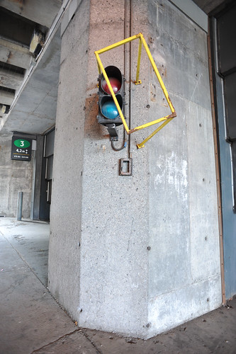
Montreal, Canada.

Curious minor urban disaster. The brace meant to prevent the signal light from being struck by a large truck or something was struck by a large truck or something and, thence, struck the object it was meant to protect.

Why do I blog this? I enjoy finding these disturbances in perfection and cleanliness. Typical, everyday moments in which a bit of history — however minor — is etched into solid metal and concrete to remind us of the below-the-radar bits of function of the city. We might call this a minor chink in the city’s urban armor battle suit thing.

Continue reading Minor Urban Disaster

David Byrne Urbanism

Saturday April 11, 21.54.27

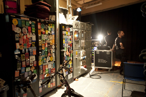
Backstage, this plus bicycles, Notingham, England.

This is a nice, succinct reflection on the characteristics of cities, and the characteristics personally likable by David Byrne, titled David Byrne’s Perfect City. Worth the quick read. The short essay also serves as a reminder for the new Byrne book, Bicycle Diaries.

Why do I blog this? It’s no big secret that the Laboratory is a big fan of David Byrne because of the music, certainly. But, also, and as importantly, for the expanse of his creative wingspan, this article being one symptom of that. It’s also quite nice to have these sorts of insights into the urban condition presented from the ground, from a bicycle, from someone who carts his bicycle wherever he goes. And, having recently completed a world tour — I mean, you have to think that this level of insight reaches way beyond tooty, snooty urban theorists. Or, maybe that’s too harsh — it has a perspective that not many others can share just for lack of on-the-ground experience. We’re not bragging, but recently while visiting family who are in David Byrne’s band, we were struck by what we overheard while heading towards the buses: OH: “We still have to load the bikes.” I asked — “Besides all this equipment, you bring bikes?” Well..naturally.
Continue reading David Byrne Urbanism

Generative Urban Design

LAIsland_001

LAMap_014

Get the flash player here: http://www.adobe.com/flashplayer

var so = new SWFObject(“http://www.db798.com/pictobrowser.swf”, “PictoBrowser”, “500”, “430”, “8”, “#E0E0E0”); so.addVariable(“source”, “sets”); so.addVariable(“names”, “LA Generative Procedural Maps”); so.addVariable(“userName”, “nearfuturelab”); so.addVariable(“userId”, “73737423@N00”); so.addVariable(“ids”, “72157622074827670”); so.addVariable(“titles”, “on”); so.addVariable(“displayNotes”, “off”); so.addVariable(“thumbAutoHide”, “off”); so.addVariable(“imageSize”, “medium”); so.addVariable(“vAlign”, “mid”); so.addVariable(“vertOffset”, “0”); so.addVariable(“colorHexVar”, “E0E0E0”); so.addVariable(“initialScale”, “off”); so.addVariable(“bgAlpha”, “71”); so.write(“PictoBrowser090818080648”);

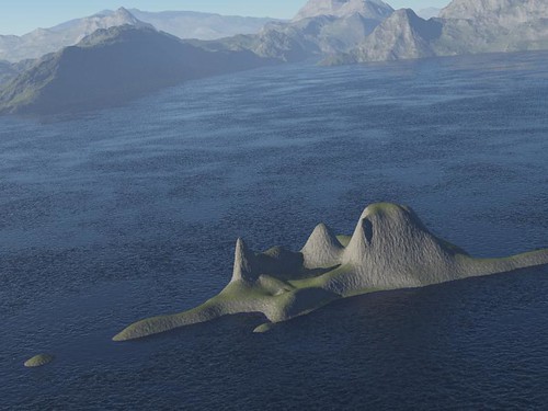
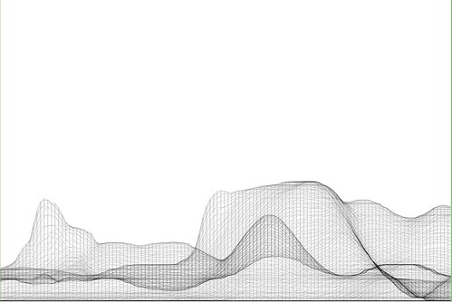
These images are from a series of generative, algorithmic sketches to describe what Los Angeles might look like as an “augmented reality.” Specifically, one view of the city from my point of view, where the topography and built environments height-density were a function of my presence. An ego city or something.

This is more an idea that has been stuck in my head and needed some expression. I am not at all sure what one does with this or how one uses it in any instrumental way except as a proper augmentation of the one canonical reality. A bit of a Kevin Lynch (Good City Form which I haven’t finished but am enjoying and, of course, The Image of the City) style map of presence, sketched from accumulated presence data rather than specifically what I imagine or how my brain conceives of urban space.

These are simple, early sketches to see how home made cartography might create density maps that reveal some sort of cartographic indication of where you have been, leaving blank or perhaps more obvious the places you have not been. Or a GPS that shows a fog-of-war map, or constructs routes for you based on a principle of exploration — routing you through areas that you have yet to see or explore.

To be continued, as always. Just curious.

Why do I blog this? But, besides that point, I am anxious to find alternative perspectives of the city, especially ones that are dynamic and produced from closer to the ground-up, rather than from the top-down. Using occupancy as a measure, or as the algorithmic seasoning seems like a Lynchian natural first step. Based on the amount of time spent in particular areas, my own personal maps should reflect this somehow, either by fogging out all the rest of the space, drawing the rest of the space as blank or, as in these sketches, altering the terrain height and the built environment’s density and building heights, etc. (Of course, these are not actual buildings from Los Angeles — it is all a thought, a sketch of these ideas. These are the things I have been thinking about, and other kinds of algorithms and/or mechanisms to materialize these ideas, such as Drift Decks, Apparatus, Personal Digital Pal’s etc.

Also, I thought I lost these sketches after complete, well-founded frustration with the absolute most crappiest piece of over-priced software I have ever come across in the whole world.
Continue reading Generative Urban Design

Manhole Compass

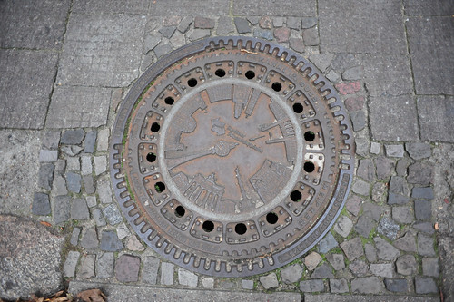
A functionally-decorative manhole cover that emulates the features of a compass rose for those who care not to navigate by dead-reckoning, rather feature or landmark-reckoning. I know these are all over the place, the image of it summoned up a recent conversation about how much built-in navigation cities should provide. The pro-argument being that it helps tourists to get around a city when they don’t have the vernacular, experienced wayfinding abilities of a native or someone who has had time to acclimate and grow accustom to the nuances of what is where. The con-argument is that these sorts of waypoints and navigation aids makes cities over mapped, removing the unexpected encounter that can only happen when you’re lost, or eroding the experience and feeling of becoming “native” and used to a city’s ways on ones own.

GPS Experiment

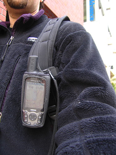
I can see something in each perspective, although I would generally prefer to leave a little more to chance when navigating a city. This photo is of me in Tokyo, 2005 after I managed to get a Tokyo map uploaded to my Garmin GPS. I had absolutely 0% navi experience in Tokyo and was pretty sure I’d get completely lost, which I did on an occasion or two, but was able to rely on the GPS to get me back on track. (There were no navigation features, just top-down POV and compass.) I’m certain it changed the experience, but there was not a whole lot left to rely upon besides my own wits and my trusty Tokyo City Bilingual Atlas.

Continue reading Manhole Compass